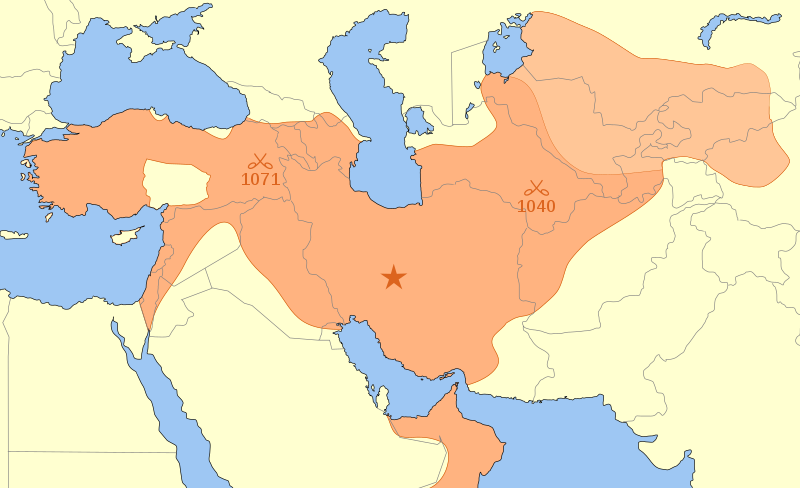
Seljuk Empire locator map
Forfatter/Opretter:
Attribution:
Billedet er tagget "Attribution Required", men der blev ikke angivet nogen tilskrivningsoplysninger. Attributionsparameteren blev sandsynligvis udeladt ved brug af MediaWiki-skabelonen til CC-BY-licenserne. Forfattere og ophavsmænd finder et eksempel på korrekt brug af eksempel her. her.
Kredit:
Eget arbejde
Shortlink:
kilde:
størrelse:
800 x 488 Pixel (165078 Bytes)
beskrivelse:
A map showing the Great Seljuk Empire at its height, upon the death of Malik Shah I in 1092.
- The capital of the Great Seljuk Empire is shown at Isfahan (Persia/Iran).
The borders of present-day countries are shown in gray.
The lighter colour in the top right represents Karakhanids.
- "In 1089, Malik Shah returned to the charge, occupied Bukhara, captured Sarakand, and imprisoned the Karakhanid Ahmed . . . whom he later reinstated as client-ruler. From that time forward, the Karakhanids who reigned in Bukhara and Samarkand did so as lieutenants of the Seljuk sultans. Transoxiana was now no more than a dependency of the Seljuk Empire."
(Grousset p. 147.) - Other areas such as the Danishmends are not shown separately.
- The locations of the Battle of Manzikert (1071) and the Battle of Dandanaqan (1040) are also shown.
Licens:
Licensbetingelser:
Creative Commons Attribution-Share Alike 4.0
Yderligere oplysninger om licens til billedet kan findes her. Sidste ændring: Mon, 26 Feb 2024 15:07:38 GMT
