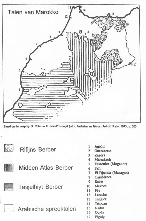
Morocco - Linguistic map

Forfatter/Opretter:
Kredit:
Eget arbejde
Own made map
Own made map
Shortlink:
kilde:
størrelse:
652 x 601 Pixel (19906 Bytes)
beskrivelse:
Linguistic map of Morocco, map drawn acc. to:
- P. Behnstedt's La frontera entre el bereber y el árabe en el Rif & Materialien für einen Dialektatlas von Nordost-Marokko, for the Berber speaking areas of Northern Morocco ;
- C. Múrcia Sanchez, La llengua amaziga a l'antiguitat a partir de les fonts gregues i llatines (details in vol.3 (annexes), p.18)
- J. Vignet-Zunz's map of Northern Morocco (see also Murcia Sanchez, vol.2, p.818) ;
- M. Lafkioui's study on Berber speaking areas of Northern Morocco (see Murcia Sanchez, vol.2, p.875) ;
- H. Ramou's map, used by B. Elbarkani in: Le choix de la graphie tifinaghe pour enseigner, apprendre l'amazighe au Maroc : conditions, représentations et pratiques (annexes partie 1, p.2) ;
- S. Chaker's article on Central Atlas Tamazight, (INALCO) ;
- M. Abouzaid, Politique linguistique éducative à l’égard de l’amazighe (berbère) au Maroc (see map, p.40) ;
- G. Colin's map ;
- Stroomer & Kossmann's map (p.1) ;
- A. Hachimi's thesis (see Boukous' map, "p.0", PDF's p.15).
Licens:
Licensbetingelser:
Creative Commons Attribution-Share Alike 3.0
Yderligere oplysninger om licens til billedet kan findes her. Sidste ændring: Sat, 23 Dec 2023 08:37:12 GMT