Map-Jungfrau-Aletsch-Bietschhorn
Forfatter/Opretter:
Nasa, worked over by de:Benutzer:Albinfo
Shortlink:
kilde:
størrelse:
282 x 291 Pixel (71824 Bytes)
beskrivelse:
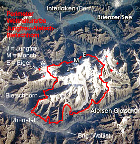
Satellite photo of Unesco World Heritage Site Swiss Alps Jungfrau Aletsch. Marked are the boundaries (Perimeter) of the world heritage site and some important objects: The mountains Bietschhorn, Eiger (E), Mönch (M) and Jungfrau (J), the Aletsch Glacier (Aletsch Gletscher), Lake Brienz (Brienzer See), the Rhône valley (Rhonetal) and the cities of Interlaken and Brig. The red plus signs indicate the area, where the world heritage site might be enlarged soon.
Licens:
Public domain
Yderligere oplysninger om licens til billedet kan findes her. Sidste ændring: Sat, 30 Mar 2024 20:31:48 GMT