Doggerland

Forfatter/Opretter:
Attribution:
Billedet er tagget "Attribution Required", men der blev ikke angivet nogen tilskrivningsoplysninger. Attributionsparameteren blev sandsynligvis udeladt ved brug af MediaWiki-skabelonen til CC-BY-licenserne. Forfattere og ophavsmænd finder et eksempel på korrekt brug af eksempel her. her.
Kredit:
Eget arbejde
Shortlink:
kilde:
størrelse:
545 x 600 Pixel (169465 Bytes)
beskrivelse:
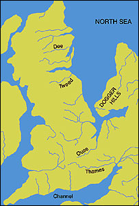
An image of the area known as Doggerland which connected the British Isles and the European continent. Loosely based on two images, found at http://www.bevpease.force9.co.uk/p.Flood_files/image002.jpg and http://humanities.exeter.ac.uk/archaeology/research/projects/title_89282_en.html, (now archived at https://web.archive.org/web/20220420042919/http://humanities.exeter.ac.uk/archaeology/research/projects/title_89282_en.html) however drawing work was all done in Illustrator by myself. Norway has been excluded from the map.
Licens:
Licensbetingelser:
Creative Commons Attribution-Share Alike 3.0
Yderligere oplysninger om licens til billedet kan findes her. Sidste ændring: Wed, 10 Apr 2024 10:53:11 GMT