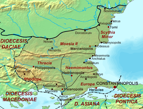
Dioecesis Thraciae 400 AD
Forfatter/Opretter:
Kredit:
Base map found at en:Topographic map#Global 1-kilometer map, otherwise self-made. Data based on maps in atlases and the internet and on contemporary sources, primarily the Notitia Dignitatum.
Note: The exact course of the provincial boundaries is very uncertain and in many cases only approximate.
Note: The exact course of the provincial boundaries is very uncertain and in many cases only approximate.
Shortlink:
kilde:
størrelse:
461 x 352 Pixel (209821 Bytes)
beskrivelse:
Map of the Diocese of Thrace (Dioecesis Thraciae) ca. 400 AD, showing the subordinate provinces and the major cities.
Licens:
Public domain
Yderligere oplysninger om licens til billedet kan findes her. Sidste ændring: Sun, 21 Apr 2024 15:36:51 GMT