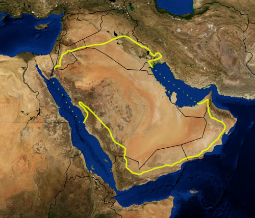
Arabian Desert
Forfatter/Opretter:
Pfly
Kredit:
NASA, plus my additions by myself.
Shortlink:
kilde:
størrelse:
500 x 428 Pixel (118571 Bytes)
beskrivelse:
This is a map showing the location of the Arabian Desert. The yellow line encloses ecoregions as delineated by the World Wide Fund for Nature: the "Arabian Desert and East Sahero-Arabian xeric shrublands", and the "Arabian Gulf desert and semi-desert" (a narrow strip along the Persian Gulf coast), and the "Red Sea Nubo-Sindian tropical desert and semi-desert" (along the Red Sea and in patches throughout the Arabian peninsula). National boundaries are shown in black. I, Pfly, made it using NASA Blue Marble imagery and ecoregion GIS data which I simplified and digitized in Photoshop.
WWF code PA1303
Licens:
Public domain
Yderligere oplysninger om licens til billedet kan findes her. Sidste ændring: Tue, 02 Apr 2024 07:18:43 GMT